

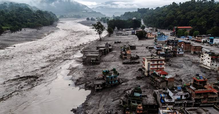
The catastrophic flash floods that struck Nepal’s Rasuwa district and Tibet’s Gyirong region on 26 August 2026 have produced one of the Himalayan region’s worst recent disasters. Hundreds of people have been killed, thousands remain missing, settlements have been destroyed and vital roads, bridges and hydropower infrastructure have been swept away. This brought attention from many users online and lead to a second major crisis, one that of psychological warfare and misinformation seeking answers to whom to blame?
While scientific investigations are still developing, sections of Indian media have rapidly framed the disaster around alleged Chinese responsibility. Questions have been raised over whether China failed to provide Nepal with an early warning, whether a geological barrier on the Chinese side collapsed, whether Chinese infrastructure contributed to the disaster, and whether Beijing withheld information from Nepal. Such questions can legitimately be investigated. However, turning them into conclusions before the scientific evidence is established risks transforming a humanitarian catastrophe into geopolitical propaganda, suggesting a clear exploitation of sensitive human emotions to a psychological warfare tactic.
The available scientific evidence currently points in a substantially different direction.
Science Points Towards a Glacial Collapse, Not a Chinese Infrastructure Failure
The most important evidence comes from independent scientific analysis. The United States Geological Survey (USGS) reported that the disaster was likely triggered by a glacial collapse in Langtang National Park on the Nepal side of the border. According to the USGS, the collapse originated in a glaciated mountain cliff on the northern side of Langtang Lirung, a mountain approximately 7,200 metres high. The collapse generated seismic energy equivalent to a magnitude-5.2 earthquake and produced a debris flow that travelled approximately 100 kilometres downstream.
Their findings suggest, “The slope failure involving a glacier generated energy equivalent to a M5.2 earthquake. The debris flow and flood travelled approximately 100 kilometers (approximately 62 miles). A second seismic event was recorded approximately 3-hours later, generating energy equivalent to a M4.2 earthquake.” (U.S. Geological Survey)
This finding is significant because early reports had interpreted the seismic signal as an earthquake. Subsequent analysis indicated that the enormous movement of ice, rock and debris itself generated the seismic signal. Nature likewise reported that scientists had linked the catastrophe to a collapsing glacier and the resulting landslide and flash flood.
The physical mechanism is therefore considerably more complex than the simplistic claim that a “Chinese” dam or infrastructure project “caused” the flood. A glacial collapse can release enormous quantities of ice, rock and water almost instantaneously. The resulting debris flow can then enter river channels, pick up additional sediment and water and travel downstream with extraordinary destructive force.
This does not mean that every question concerning infrastructure, climate change or disaster preparedness should be dismissed. Himalayan development deserves scrutiny. But scrutiny is different from assigning causation without evidence especially to shift attention from a population in crisis to causing distress and lack of security.
The “45-Minute Warning” Narrative Requires Greater Scientific Caution
One of the most repeated allegations in Indian media and online commentary is that China knew about the disaster approximately 45 minutes before Nepal and deliberately or negligently failed to warn its neighbour.
The figure itself has circulated widely. CNN, for example, reported that a group of people at the Gyirong crossing had their last recorded communication approximately 45 minutes before the flooding occurred in that area. However, this does not establish that Chinese authorities had 45 minutes of actionable scientific warning.
There is a crucial distinction between observing that a disaster has begun and predicting a disaster before it occurs.
A rapidly developing glacier collapse is not equivalent to a conventional monsoon flood for which river gauges can provide predictable lead time. The USGS describes the 2026 event as a sudden glacial collapse that generated an extremely rapid debris flow.
Moreover, Nepal’s own monitoring network encountered serious difficulties. Reports citing Nepal’s flood forecasting authorities indicate that automatic monitoring stations in the upper Bhote Koshi stopped transmitting before they could issue alerts. The extraordinary speed of the flood meant that even personnel attempting to warn communities faced extreme danger.
This is why the appropriate question is not simply, “Why didn’t China give Nepal 45 minutes?” It is: What information was technically available, when did authorities receive it, how quickly was it communicated, and what warning time was physically and practically possible?
Those questions require telemetry records, satellite imagery, seismic data, river-gauge information and communication logs, not television speculation or social media gossip.
China’s Position: Cooperation Rather Than Blame
The Chinese Embassy in Nepal rejected allegations that China had failed to issue a warning and also rejected claims that the collapse of a geological-disaster barrier on the Chinese side caused the destruction in Nepal. The embassy described both allegations as false and urged the two countries to focus on rescue and relief rather than mutual accusations, especially when humanitarian support is what deem required for the moment.
Its message “accusation helps nothing, cooperation saves lives” is particularly relevant during a disaster of this magnitude.
China itself suffered substantial losses. The disaster devastated the Gyirong area and left hundreds of people missing on the Chinese side, including foreign nationals. Chinese emergency personnel, military and rescue teams were deployed to the affected region despite extremely difficult terrain and continuing flood hazards.
China’s response therefore should not be reduced to a political defence of Beijing. It is also important to recognize that Chinese communities and infrastructure were themselves directly affected by the same catastrophic event.
Chinese rescue teams worked through mud, debris and unstable terrain to reach the destroyed border area. Financial and humanitarian assistance was also provided to Nepal following previous Himalayan flood disasters. In July 2025, for example, the Chinese Red Cross provided emergency cash assistance to the Nepal Red Cross to support flood relief and reconstruction in Rasuwa.
While sections of Indian media were rapidly debating Chinese responsibility, China was simultaneously mobilizing rescue personnel and emergency resources. More than 2,100 Chinese personnel were involved in rescue operations, Chinese teams reached the devastated Gyirong border complex, and Beijing offered emergency assistance to Nepal, including 50 tons of relief supplies delivered by two cargo aircraft.
The contrast is striking: while the disaster was being turned into a geopolitical blame game in parts of the media, China was dealing directly with the humanitarian consequences on the ground.
The broader picture is consequently one of a country facing a disaster alongside its neighbor, not that of a powerful state inflicting a disaster upon a weaker one.
The Infrastructure Argument: A Political Claim Is Not a Causal Finding
Another recurring narrative has attempted to connect the catastrophe to China’s infrastructure development in Tibet. Roads, hydropower projects, border facilities and proposed connectivity projects are cited as evidence that Chinese development is destabilising the Himalayan environment.
Environmental concerns in the Himalayas are legitimate and deserve serious scientific attention. Large infrastructure projects anywhere in fragile mountain environments can potentially increase exposure to landslides, alter drainage patterns or place populations and economic assets in hazard-prone locations.
But that general proposition does not prove that Chinese infrastructure caused this particular flood.
The scientific evidence currently available identifies a natural glacial collapse and subsequent ice-rock avalanche as the trigger. Nature’s assessment likewise connects the disaster to glacier instability and the increasing risks associated with a warming high-mountain environment.
In fact, climate change provides a far stronger scientific framework for understanding why such disasters may become increasingly dangerous. Rising temperatures are destabilising glaciers, permafrost and high-altitude slopes throughout the Hindu Kush Himalaya. Nepal has already experienced substantial glacier loss, while scientists warn that warming can increase the probability of sudden high-altitude hazards.
Reducing the entire event to ‘Chinese construction caused the flood’ therefore obscures a much larger regional climate-security problem.
The Media Narrative and the Politics of Blame
The most concerning aspect of the coverage is not that Indian media raised questions about China. Journalism should question governments including China, India and Nepal.
The problem emerges when allegations are presented with greater certainty than the available evidence permits, portraying as though India was waiting to turn the tragedy into an anti-China controversy.
Reports suggesting that China deliberately withheld information, that Chinese infrastructure triggered the disaster or that Beijing “knew” a catastrophic flood was coming require evidence. At present, there is no publicly established scientific finding demonstrating that Chinese infrastructure triggered the 2026 disaster.
Indeed, the emerging scientific record points in another direction. USGS analysis places the triggering glacial collapse on the Nepal side, while satellite and seismic analysis have independently supported the interpretation of an ice-rock collapse rather than a conventional earthquake or infrastructure failure.
This distinction is especially important because “sensational reporting” can damage relations between Nepal and China at precisely the moment when cross-border cooperation is most necessary.
The Himalayas are not divided by the political boundaries drawn on maps. Rivers, glaciers, landslides and atmospheric systems cross borders. Nepal, China and India are therefore connected by the same environmental risks.
The Real Lesson: Better China-Nepal Cooperation
The disaster does reveal an important weakness: Himalayan countries need stronger trans-boundary disaster-warning mechanisms and mechanism for tackling similar situations stricken by climate change.
The World Meteorological Organization has already been working with Nepal to strengthen flood early-warning systems, including standardised warning protocols and communication mechanisms. ICIMOD has similarly highlighted gaps in regional flood-warning communication and the importance of improving technical, institutional and community-level preparedness.
Rather than using the tragedy to manufacture hostility between Nepal and China, the disaster should become an opportunity for deeper cooperation.
China and Nepal could strengthen real-time glacier monitoring, install additional high-altitude sensors, exchange satellite and hydrological information, develop automated emergency-alert channels and conduct joint scientific investigations following major Himalayan hazards.
Such cooperation would serve Nepal’s interests far more effectively than media-driven accusations.
Evidence before Allegations
The Nepal flood was first and foremost a human tragedy. Communities on both sides of the border suffered devastating losses. The scientific evidence currently available indicates that a sudden glacial collapse and resulting debris avalanche played the central role in triggering the catastrophe. The claim that Chinese infrastructure caused the disaster has not been scientifically established. Likewise, the widely circulated ‘45-minute warning’ argument should not automatically be transformed into an accusation of deliberate Chinese negligence. Establishing whether meaningful warning was technically possible requires detailed scientific examination of monitoring data, satellite observations, seismic records and communication timelines.
China has a legitimate responsibility to cooperate transparently with Nepal, just as Nepal has a responsibility to strengthen its own disaster-monitoring and response systems. India, meanwhile, has an equally important responsibility to report Himalayan disasters responsibly rather than allowing regional strategic competition to dominate humanitarian reporting.
The tragedy should not become another front in an information war.
The Himalayas do not recognise political borders. Neither should disaster science.
At a time when climate change is making glaciers and mountain ecosystems increasingly unstable, the rational response is not accusation but cooperation.
Read More Articles:
Fact Check: Old Shabbar Zaidi Video Misleads on CPEC
Fake Claim Exposed: Diamer-Bhasha’s 4,500 MW Power Component Is Not Cancelled